COVID-19 Status Hub – Kenya
The JKUAT Covid-19 Status Hub displays generated predictive disease models, index maps, Spatial Real-Time Presumptive Covid-19 visualizations pages among other pages.
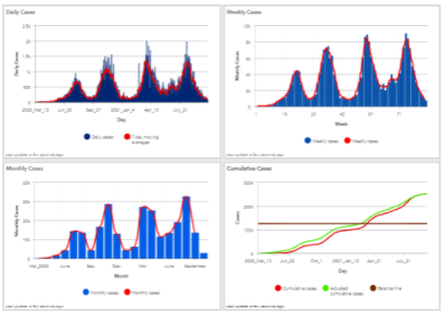
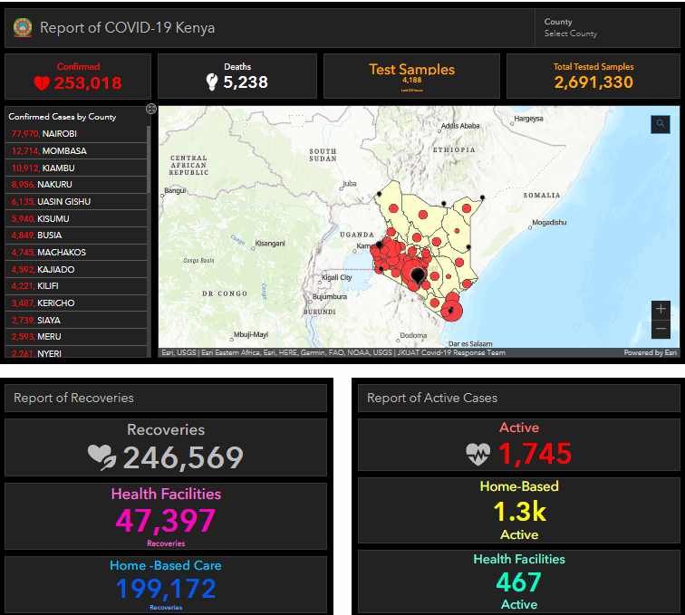
One can access statistics on the total number of confirmed cases, active, recovered or dead cases, gender, local or foreign, daily confirmed cases, vaccine dispensation, the evolution of coronavirus cases in Kenya and overtime and their distribution by counties as well as global statistics dating back to when the first Covid-19 case in the country.
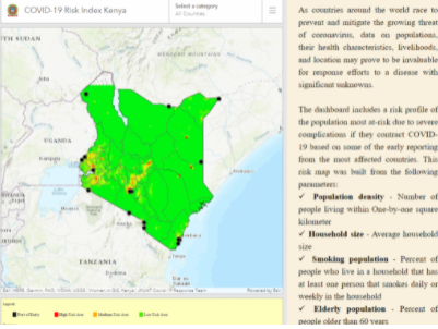
The major maps include case map and risk index map that display risk profile of the population in Kenya up to the ward administrative level across all counties as well as capture Border points (Kenya’s entry points) where entry and exit traffic is expected to be very high and people at these zones are at most at-risk due to severe complications if they contract COVID-19 based analysis made from reported cases.
A facility health resource map that displays distribution of various facilities in the country and an isolation center map to create awareness to the public on where they can get COVID-19 treatment safely.
The Hub has pages that include the spatial Real-Time Presumptive Covid-19 Tracker application (a self-test check that designates low, moderate to high risk in regard to suspected cases). The application is a self-administered health test that picks a person’s location and map it on to the dashboard. The ministry of health can then use this information relayed to the national map to make decisions such as undertake targeted mass testing in an area flagged by the map.
The Hub provides a one-stop shop for various dashboards showing data analytics products critical for making informed-policy decisions in terms of making executable decisions that help prevent and mitigate the growing threat of coronavirus.